

Water Safety APP
The Water Safety APP developed by Twin Fin Consulting, is a free tool designed to help land managers quickly and consistently assess coastal risk. Whether for a single day’s conditions or a broader seasonal review, the APP provides evidence-based insights to support safer, smarter decisions.
What does the APP do?
Simple Risk Assessments
Risk assess the locations you manage, assess the need for controls and prioritise evidence based interventions.

Record and Report
Get an instant risk rating that can be saved and edited in the app. Generate a high quality .pdf emailed directly to your inbox.
Flexible Timeframes
Generate reports for a point in time or consider your risk over weeks, months or years, it’s up to you.

Why it matters
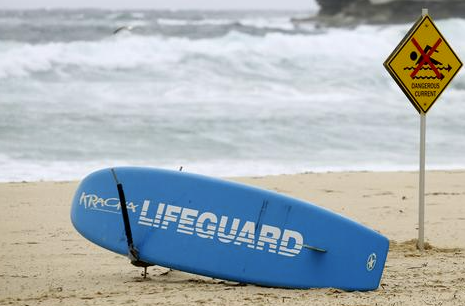
Coastal environments are among the most popular destinations for recreation and leisure, drawing millions of visitors each year to enjoy beaches, rock platforms, and the open ocean. While these environments offer great beauty and enjoyment, they also present significant safety risks. In 2023/24, 150 coastal drowning deaths occurred in Australia, with over half of these incidents taking place on beaches. The dynamic and unpredictable nature of coastal environments, combined with the inherent risks posed by waves, tides, and currents, make coastal safety management a critical concern for land managers.
Coastal land managers face the difficult task of balancing the need for public safety with limited resources. Existing risk models provide valuable insights into hazard assessment, but they are often too complex, require subjective data inputs, and focus heavily on the application of safety controls. These limitations make such models difficult for day-to-day operational use by land managers, who need an assessment tool that is both simple and reliable.
The Coastal Operational Risk Assessment (CORA) model addresses this need by offering a streamlined approach to coastal water safety risk management. Built on objective, readily available data sources such as beach hazard ratings and real-time visitation statistics, CORA simplifies risk assessments while maintaining sufficient accuracy to support decision-making. Designed specifically for land managers, CORA empowers users to evaluate risk with ease and to apply appropriate safety measures that maximize the efficient use of resources.
How does it work?
Noting that all coastal locations are dangerous, and the risk of drowning is pervasive, a coastal water safety risk assessment process needs to be simple to use by land managers in an operational environment. It should rely primarily on objective, available data to reduce subjectivity of results but must be accurate enough to inform decision making.
Most Land Managers are familiar with consequence-likelihood matrices as part of their corporate risk management systems. I propose that coastal water safety risk assessments be performed in the same manner.
Hazards
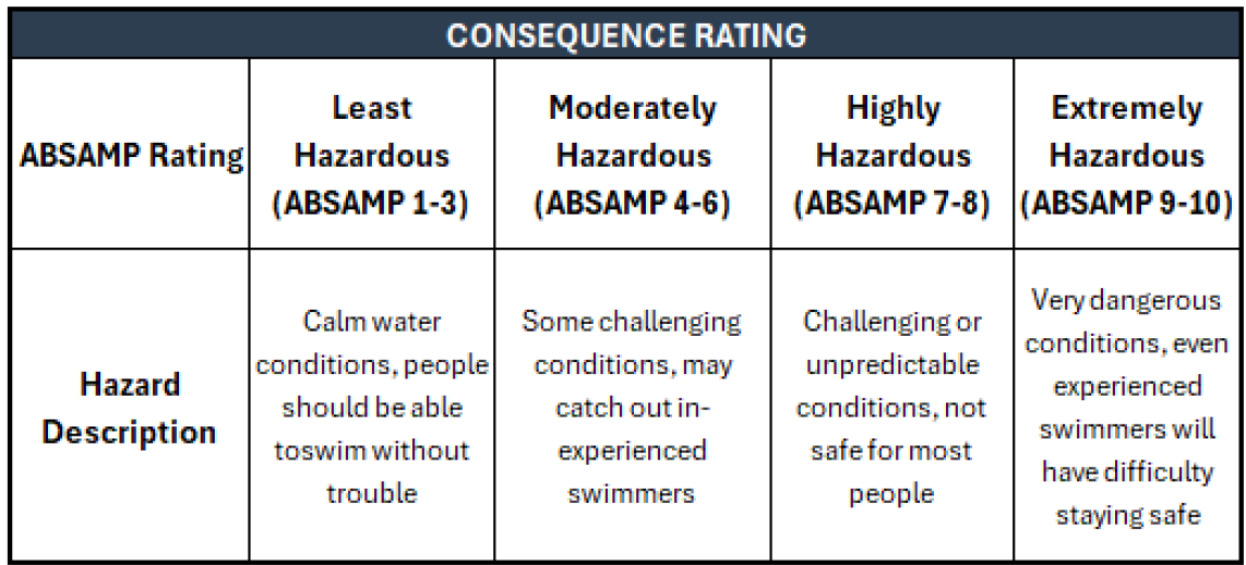
Whilst many hazards exist and can vary from beach to beach, the ABSAMP rating has been developed and tested through numerous studies and is a well-established method of determining a coastal hazard rating. All the exemplar models use a form of the ABSAMP hazard rating to determine beach hazard rating. The ABSAMP model takes into account a range of beach hazards including Beach geomorphology, Wave size, Tide state (for tide modified and tide dominated beaches and a note that rips become stronger with falling tide.) and Local hazards such as rocks and reefs
The ABSAMP hazard rating is an excellent method to determine the hazardousness of a coastal location and can be used as the “risk consequence” axis of a risk assessment matrix. The established ABSAMP hazard categories fit neatly into a 4-column risk consequence rating table from least hazardous to highly hazardous (as defined in the ABSAMP model) with descriptions added for each category.
RISK RATING
The consequence (hazard) and likelihood (visitation) assessments can then be combined into a simple risk assessment matrix. This methodology is generally well understood by land managers, can be applied at a point in time or modally across a year, season, month, day or hour.
This assessment can use historical, live or forecast data and, most importantly, the data inputs are all readily available. The model is accurate enough to differentiate locations and to inform decision making without being overly complicated for use in an operating environment. This new model aligns with existing risk assessment approaches, familiar to land managers, ensuring that it serves as a practical, reliable, and effective tool in coastal safety management.
By adopting a simpler, data-driven approach, CORA enables land managers to prioritise locations through evidence-based decision-making, and apply appropriate controls based on accurate and accessible information.
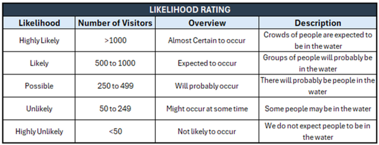
LIKELIHOOD
The simplest way to determine the likelihood of a people being exposed to the coastal safety hazard is to assess visitation. Visitation is highly variable based on weather, season and day of the week amongst other factors. As with swell, which is also highly variable, the simplest approach is to assess visitation at a given time and then to consider the modal state over the period of assessment.
This assessment is at the core of other models such as the Lifeguard Service Level Calculator, Signs as Remote Supervision, the RNLI total service concept and the SLSNSW Supervision and Surveillance Model which can give us a starting point for category thresholds in a likelihood matrix.

DISCLAIMER: The CORA Water Safety App provides decision-support only. It should not be relied upon as the sole basis for operational, legal, or safety decisions. Land managers remain responsible for implementing appropriate controls and ensuring compliance with relevant regulations, policies, and standards.”
Want to know more?
If you’d like to know more about the Water Safety App, need more detailed risk assessments, are interested in exploring visitation monitoring technologies, or simply want support with managing coastal safety challenges, we’d love to hear from you. Twin Fin Consulting works with councils, agencies, and land managers to turn complex data into practical insights. Please reach out to discuss how we can help.